Using GIS to Analyze the Development of Public Urban Green Spaces in Hamburg and Marseille (1945 - 1973)

Geographic Information Systems (GIS) are a powerful tool for spatial analysis. In historical research GIS are used for mapping, georeferencing, and data analysis. Layering information offers new ways to evaluate historical data and construct arguments. But GIS offer a myriad of choices for data modeling and visualization, so users should remain critical and conscious of their entire workflow processes. In the following, I employ the SWOT (Strengths, Weaknesses, Opportunities, Threats) analysis framework to systematically evaluate the implications of using GIS in historical research. The development of public urban green spaces in Hamburg and Marseille from 1945 to 1973 serve as useful case studies. In drawing on my experience in employing GIS methods to analyze post-war green spaces, I discuss close and distant reading techniques applied to GIS models, potential implementation of AI with GIS methods, and the multiple ways to model spatial data and create historical narratives.The goal is to provoke critical thinking about when using GIS genuinely supports research beyond producing impressive visuals, how it aids hypotheses and arguments, and how it can change the way historians work with their sources and think about their data.
GIS, Public Urban Green Spaces, Hamburg, Marseille, History of Urban Planning
Introduction
GIS (Geographic Information Systems) have become increasingly valuable in spatial history research since the mid-1990s, and is particularly useful for analyzing socio-spatial dynamics in historical contexts (Kemp 2009, 16; Gregory and Ell 2007, 1). My PhD research applies GIS to examine and compare the development of public urban green spaces, namely public parks and playgrounds, in the port cities of Hamburg and Marseille, between post-WWII urban reconstruction and the First Oil Shock in 1973. The management and processing of data concerning green space evolution in GIS allow visualization of when and where parks were created, and how these reflect socio-spatial differentiations. This layering of information offers ways to evaluate historical data and construct arguments, while also helping communicate the project to a wider audience. To critically assess the application of GIS in historical research, I will use the SWOT (Strengths, Weaknesses, Opportunities, Threats) analysis framework. This popular business consultancy approach (Minsky and Aron 2021) serves here as a structure for systematic reflection on how digital methods can enhance historical research and where caution is needed. The goal is to provoke critical thinking about when using GIS genuinely support research beyond producing impressive visuals, and to explore the balance between close and distant reading of historical data.
Strengths
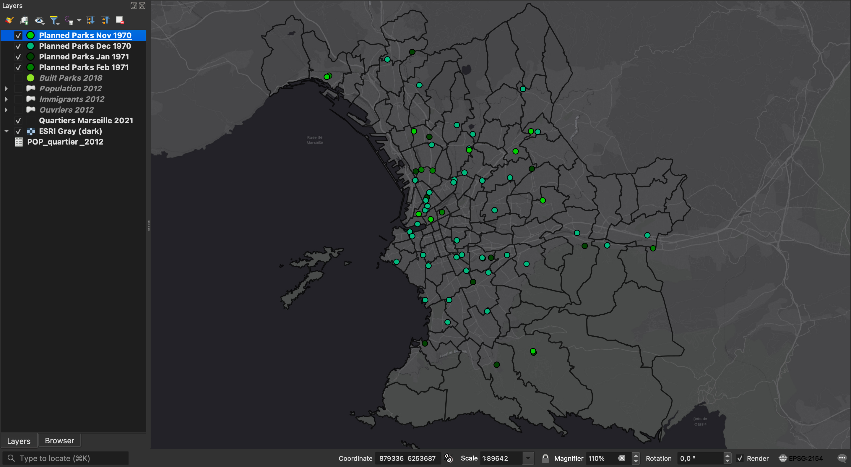
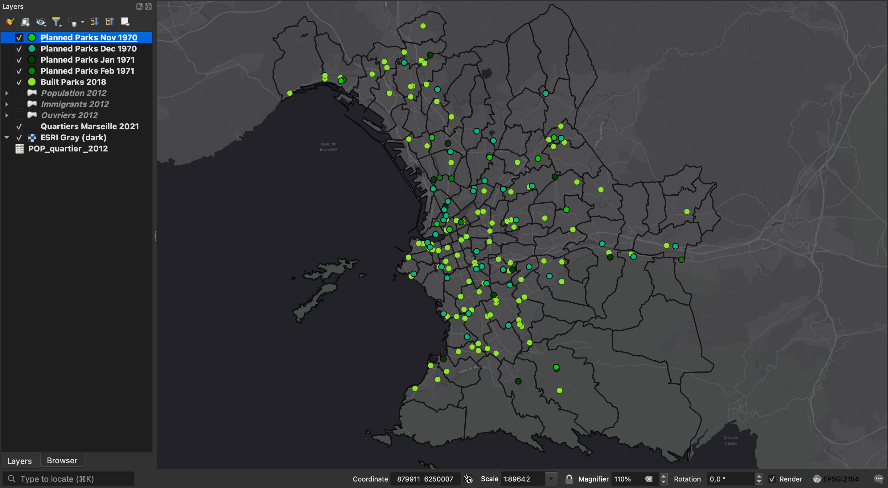
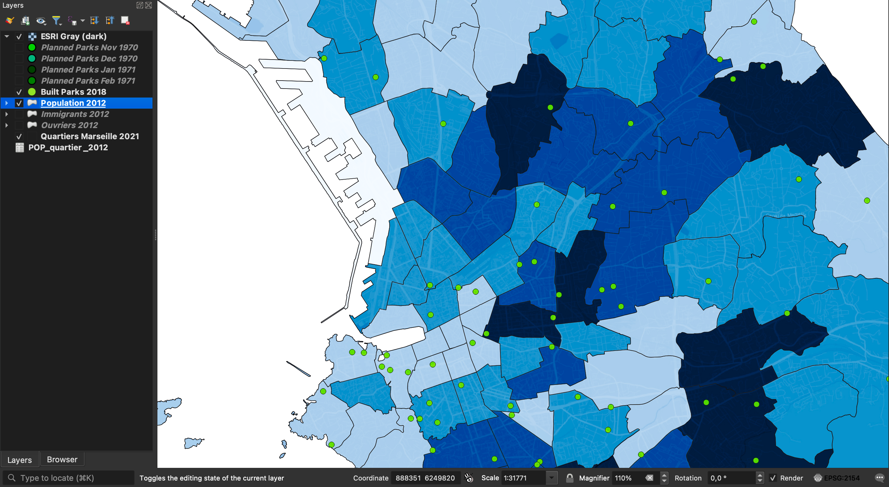
GIS are composed of layers of data sets and are mainly used for mapping, georeferencing, and data analysis (e.g. spatial analysis). The data can be varied in what it represents but must be linked to spatial parameters for it to be positioned in a visualization for analysis of spatial information (Wheatley and Gillings 2005, 1, 8). GIS layers for historical studies can be viewed as models of data sets. They represent specific topics in time and space simplistically, and spark reflection (Van Ruymbeke 2021, 8). The screen shot of my QGIS workspace (Figure 1) shows the city of Marseille with parks marked in various stages of planning in the early 1970s. This was the time when longstanding Mayor Gaston Defferre launched the large-scale greening initiative Mille Points Verts pour Marseille (Gassier 1971). Defferre and his team’s goal was to react to a growing ecological awareness and increase the number of green spaces for a more livable city (Chelini 1971). They also organized events to include and educate citizens and to garner their support for the upcoming elections (Anonymous 1971). The majority of parks created within Mille Points Verts remain until today, with only a handful of additional parks added after the mid-1970s. This is visible when the layer with parks and gardens from a 2018 dataset provided by the government of Marseille is selected (Figure 2). The strength of GIS layering is evident when we apply distant reading techniques: skimming over the model we see a display of spatial relations of park distribution and location as well as their connection to time.
In order for this visualization to take shape, I produced and assembled data. Specifically, I selected data and went through the process of closely reading my historical sources, learning to understand them and to think through their meaning. In this way maps are social documents. By themselves, they do not reveal anything yet. But by superimposing visualizations, GIS can reveal thinking processes of the data curators and map creators (cf. for example Jones 2021).
Weaknesses
The curation of data, although an important and empowering step for the historian and GIS researcher, also reveals the weaknesses of GIS: the mismatch between GIS requirements (in terms of data structuring and quality) and the imperfection of historical data. GIS software is created for geographers, not historians. Everything in GIS is structured data and therefore cannot handle ambiguities natural to historical sources. Sources in whatever form they are collected by the historian first must be organized, selected, tabularized, geocoded and/or georeferenced (Kemp 2009, 16–17). The caveat here is that a historian’s data is hardly ever complete. Missing records shape both what we can and cannot analyze – especially when working with GIS. In historical narration on text the researcher can explain gaps and postulate why this may be the case. GIS do not allow for gaps and thus we can only produce models and visualizations with the numerical evidence available.
The visualization presented here helps to model different states of an object: the park. As my data is not complete, discrepancies between the mapped data and the on-the-ground reality occur, especially since the planned parks had vague names sometimes only matching the name of an entire neighborhood. This raises the question of how to capture temporality. How can the aspect of time appear on a two-dimensional visualization? Rendering the time layer onto the spatial one demands creativity and an awareness that time is something constructed (Massey speaks of “implicit imaginations of time and space” Massey 2005, 22).
From the map making perspective, time significantly impacts the creation process. GIS work is time-consuming and labor-intensive. It involves meticulous manual searching, assembling, and layering of data. However, linking to the overarching topic of this conference, AI may offer new possibilities. Tools such as Transkribus allow users to apply machine learning to filter specific elements from document sets. LLMs can then process this information into CSV files for GIS software. While not yet revolutionary, as these tools evolve, AI could become useful in extracting numerical evidence from textual sources. For geocoding of places, AI would greatly aid efficiency and relieve the researcher of tedious manual work. However, at this point, LLMs such as Claude AI and ChatGPT still hallucinate considerably.
Opportunities
AI-assisted data extraction presents a gateway to think about opportunities. Researchers could focus more on experimenting with design and layering by automating time-consuming tasks. For example, mapping supports spatial thinking and perception by integrating the crucial ‘where’ element: Where are specific features located? How near or far is one place from another? Depending on what obstacles or facilitators are in place a park may be close in measured distance but far in terms of accessibility if there is no bridge or tunnel to e.g. cross a motorway, or water element. Therefore, how are different locations related? How can we perceive and understand distance?
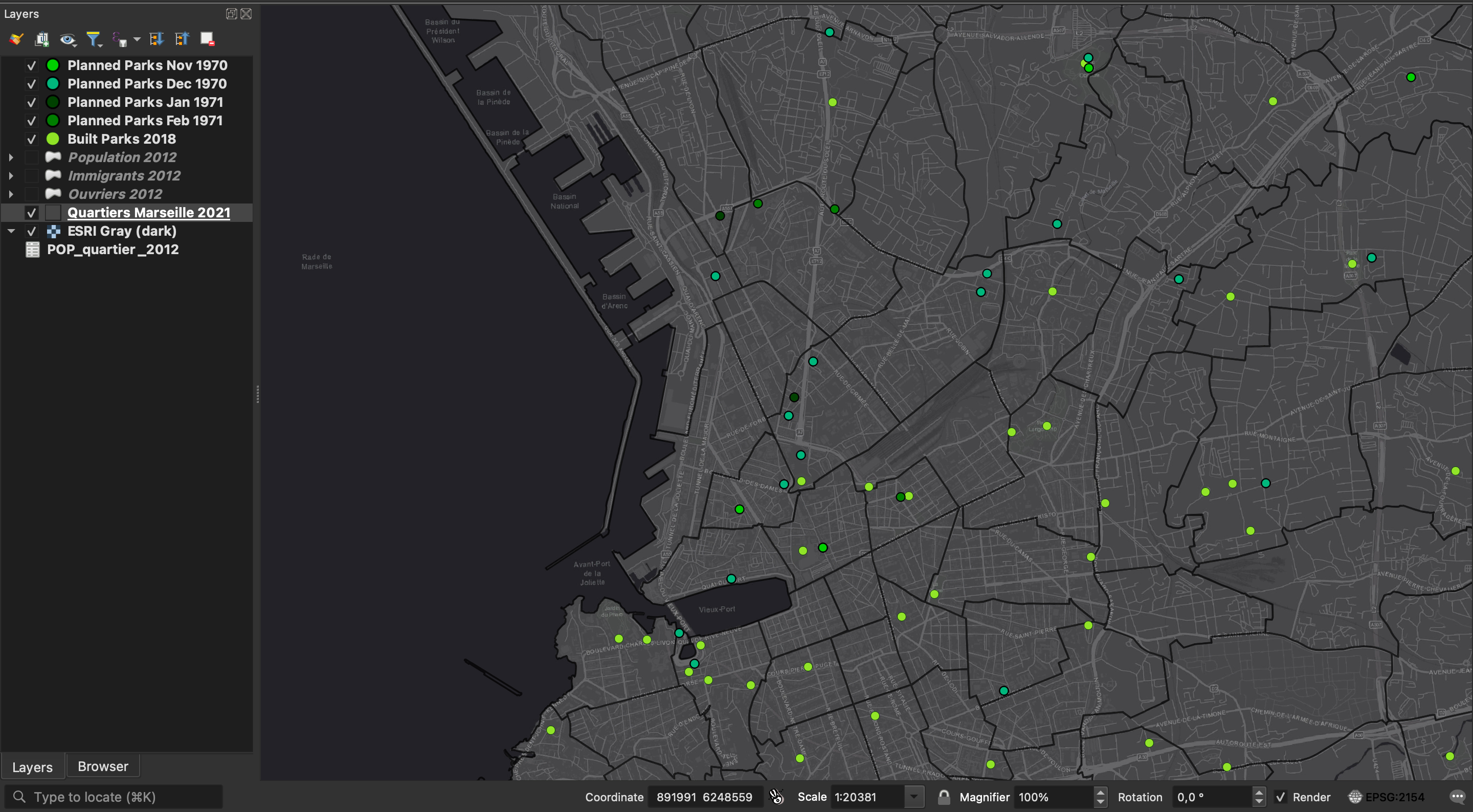
The screenshot here shows a handful of ‘wheres’ (Figure 3). They reveal where the majority of parks are located, their proximity to neighborhoods, the types of surrounding communities, and their connections to amenities and public infrastructure. This approach enables comparisons across different scales. For instance, I can compare park distribution between Hamburg and Marseille and track their development over time.
These questions prompted by the use of GIS direct both user and observer back to the original sources for close reading. A GIS model can spark interest in a topic and motivate the researcher to dig deeper on what these layers mean and how they were created. Ideally GIS should be used as a starting point for in depth analysis. In the case of Marseille and Hamburg, the development of public urban green spaces was what inspired me to look more closely at the historical circumstances. Hamburg, for instance, has a long history of creating expansive green areas with the support of private patrons. Marseille does not have a comparable patronage system. Instead, municipal expropriation rendered private villas and their gardens public.
GIS are a powerful tool that serve multiple functions in research (Wheatley and Gillings 2005, 8). They “can play a role in generating ideas and hypotheses at the beginning of a project” and serve as valuable instruments for analysis and evaluation (Brewer 2006, S36). By modeling research hypotheses and findings, e.g. maps can be used to effectively communicate to diverse audiences – from the general public to specialized groups such as urban planners and municipal governments, relevant to my field of historical urban planning research.
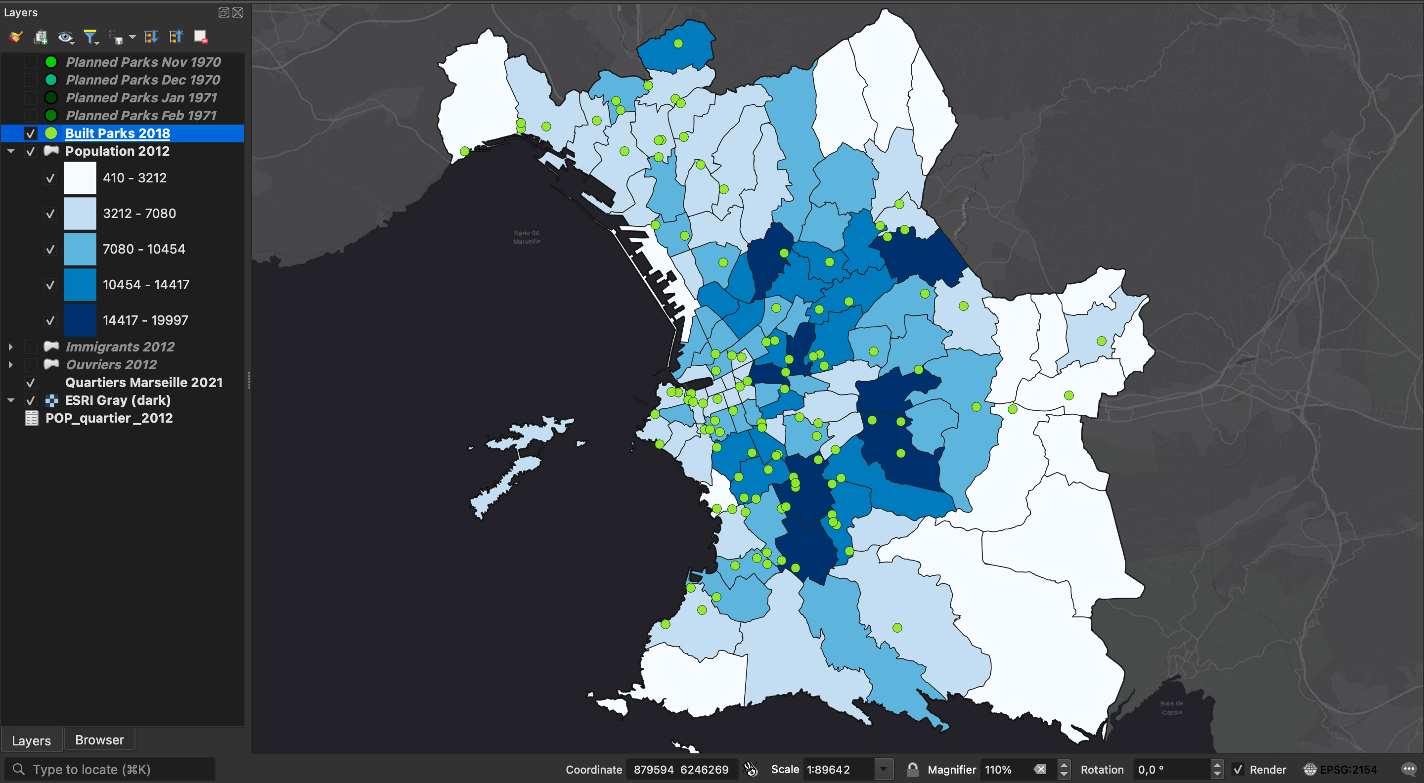
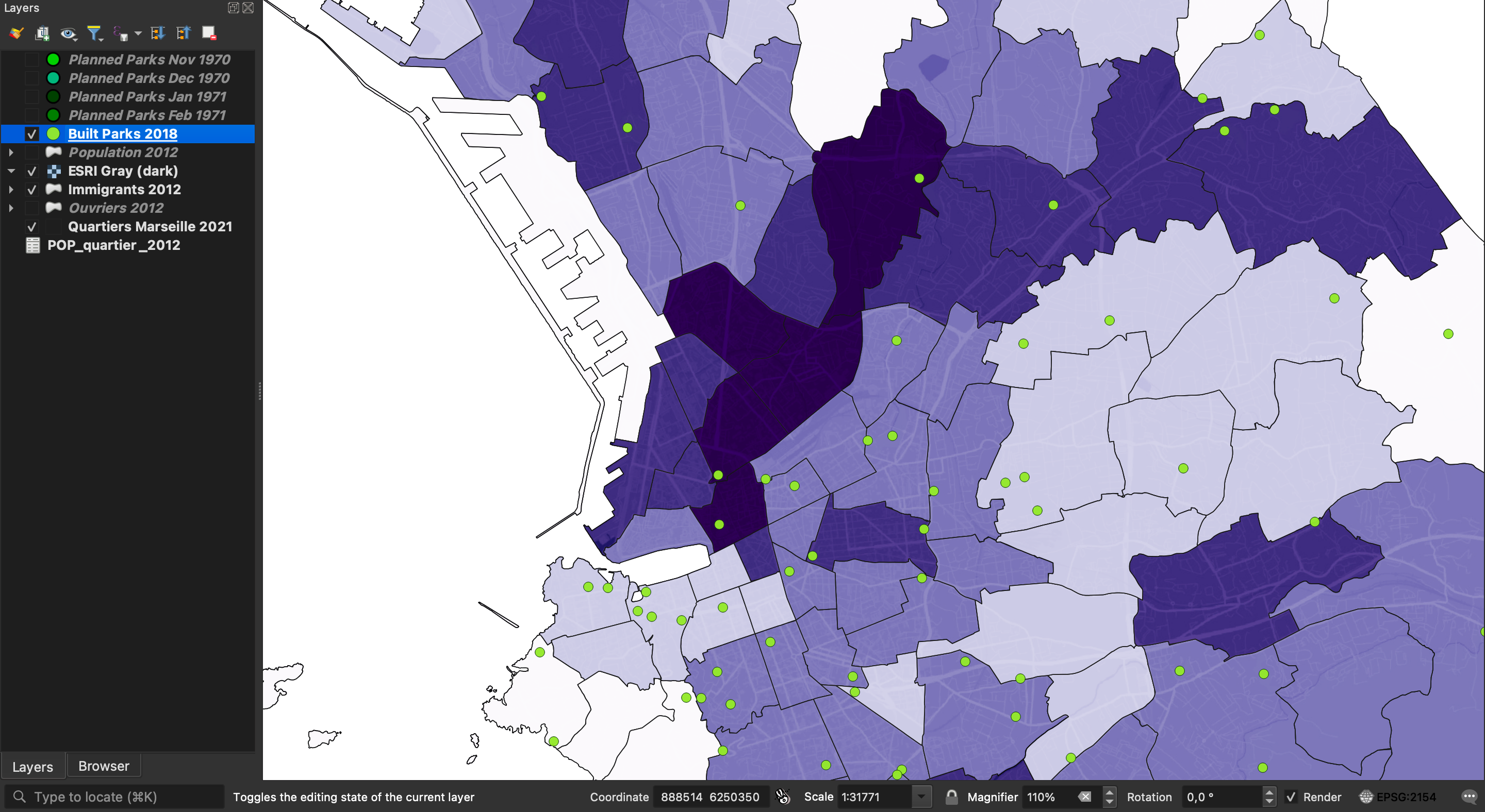
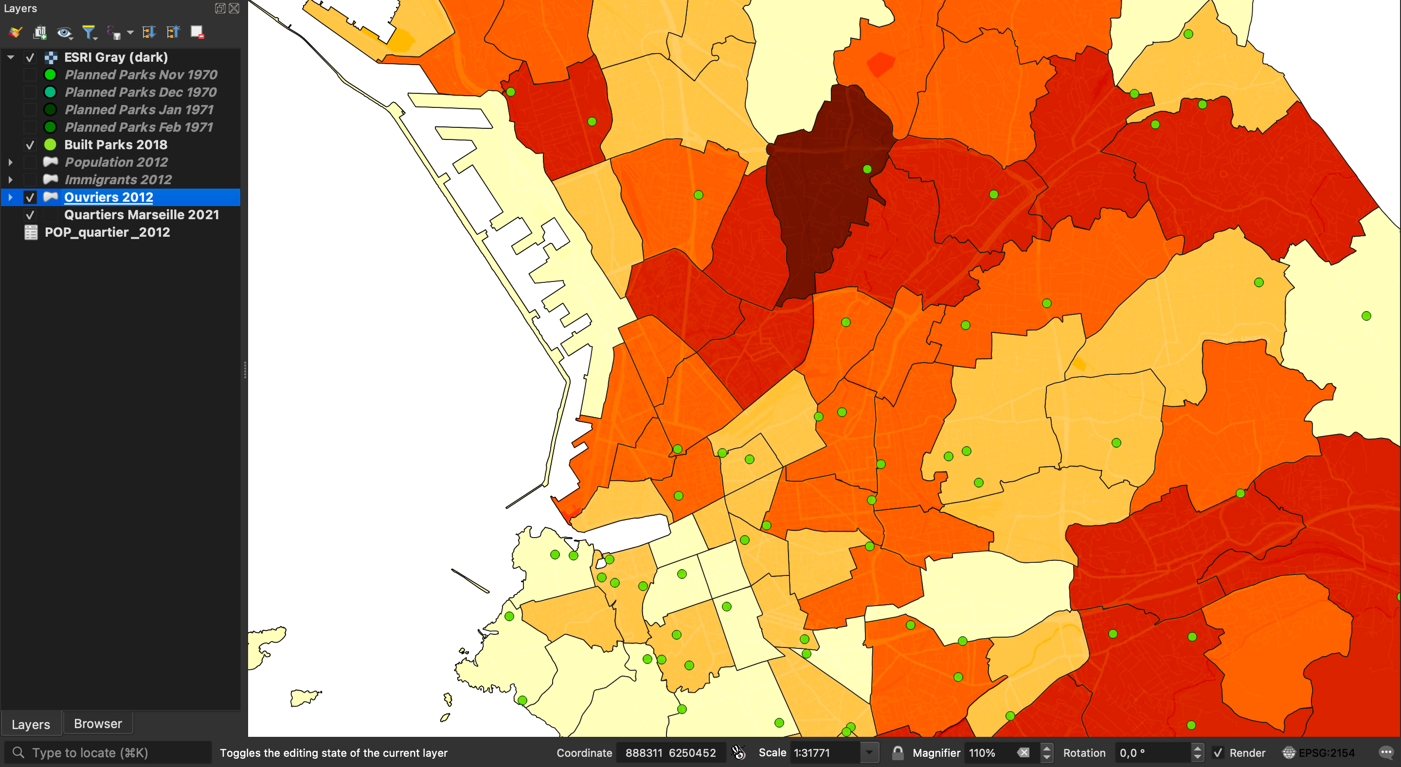
A particularly compelling aspect of GIS is their ability to visually represent power relations (Figure 4). This feature bridges the gap between historical analysis and contemporary urban planning, making it an invaluable tool in understanding the evolution of urban spaces. The visualization of Marseille reveals that the majority of parks are located towards the center and south of the city and does not necessarily correspond to the population density. The south of Marseille is where villas abound and thus the upper and upper-middle class live. The majority of the HLM (housing at moderate rent) are located towards the north, where living conditions are condensed, and political representation is low. What is more, if I select the layers showing where most immigrants and workers live today, a lack of green spaces is visible (Figure 5, Figure 6, Figure 7).
Connecting this once more to close reading of the sources: when Mille Points Verts was launched, planners scavenged locations for green space creation. The HLM neighborhoods were marked as unsuitable for participation in this program: People living in social housing would “misuse” the parks by playing soccer on them or walking across the grass (Anonymous 1970). This shows complexity of space perception and power imbalance (Van Ruymbeke 2021, 7).
Threats
Yet all these opportunities are ambiguous and “entrusting machines with the memory of human activity can be frightening”. The last element of the SWOT analysis, threats, rounds off these reflections. Although it is crucial to encourage critical thinking through the mapping of, for example, political representation and wealth distribution of a city it also shows my personal convictions. I wish to demonstrate which voices where not heard in the planning of these spaces, which people were not considered when decisions were made. I am biased when I start with the premise that there is inequality. The map, objective as it may seem, never is. The book How to Lie with Maps provocatively shows the power of maps to create a strong, and perhaps deceiving, narrative:
“Map users generally are a trusting lot: they understand the need to distort geometry and suppress features, and they believe the cartographer really does know where to draw the line, figuratively as well as literally. […] Yet cartographers are not licensed, and many mapmakers competent in commercial art or the use of computer workstations have never studied cartography. Map users seldom, if ever, question these authorities, and they often fail to appreciate the map’s power as a tool of deliberate falsification or subtle propaganda” (Monmonier 1996, 1).
People working with GIS can have all kinds of skill levels and interests. I, for example, am not a GIS specialist and relatively new to using the tool. Still, I can easily manipulate my model to paint various pictures, if I wish to do so. I can turn on different layers and focus on the number of immigrants per neighborhood, I can change the classification for the choropleth map and create entirely different impressions, or I can simply change the basemap and take away the context of terrain, transportation systems, etc. (cf. Figure 4). The quote speaks of an almost blind trust in maps, which shows once more that we must always be critical observers of the things we consume and historians should always want to be curios fact checkers.
A map is a series of decisions and it reflects the biography of both the maker and the observer. It is the responsibility of the historian working with GIS to be as transparent as possible regarding the choices made to display a historical development or state. It is the responsibility of the observer to use the map as a starting point for close reading, interpretation and analysis rather than the end point and a fact. We must remember “80% of GIS is about transforming, manipulating and managing spatial data” (Jones and Schiel 2022).
Conclusion
In conclusion the use of GIS in historical research and analysis requires the researcher to stay true to the principles of the craft of the historian: source criticism, the ability to subsume information, create a strong narrative, document the process of source manipulation and proper source citation. As historians we should be aware of the power of storytelling – no matter which medium we use. An audience’s spatial understanding can be enhanced via GIS models, serving as a support system of sorts. All the more reason why GIS in historical analysis must be used and consumed critically and consciously. By embracing this complexity, we can use GIS for historical reflections, enhancing our understanding of spatial and temporal dynamics in historical contexts.
References
Reuse
Citation
@misc{schmid2024,
  author = {Schmid, Eliane},
  editor = {Baudry, Jérôme and Burkart, Lucas and Joyeux-Prunel,
    Béatrice and Kurmann, Eliane and Mähr, Moritz and Natale, Enrico and
    Sibille, Christiane and Twente, Moritz},
  title = {Using {GIS} to {Analyze} the {Development} of {Public}
    {Urban} {Green} {Spaces} in {Hamburg} and {Marseille} (1945 - 1973)},
  date = {2024-09-12},
  url = {https://digihistch24.github.io/submissions/450/},
  doi = {10.5281/zenodo.13903914},
  langid = {en},
  abstract = {Geographic Information Systems (GIS) are a powerful tool
    for spatial analysis. In historical research GIS are used for
    mapping, georeferencing, and data analysis. Layering information
    offers new ways to evaluate historical data and construct arguments.
    But GIS offer a myriad of choices for data modeling and
    visualization, so users should remain critical and conscious of
    their entire workflow processes. In the following, I employ the SWOT
    (Strengths, Weaknesses, Opportunities, Threats) analysis framework
    to systematically evaluate the implications of using GIS in
    historical research. The development of public urban green spaces in
    Hamburg and Marseille from 1945 to 1973 serve as useful case
    studies. In drawing on my experience in employing GIS methods to
    analyze post-war green spaces, I discuss close and distant reading
    techniques applied to GIS models, potential implementation of AI
    with GIS methods, and the multiple ways to model spatial data and
    create historical narratives.The goal is to provoke critical
    thinking about when using GIS genuinely supports research beyond
    producing impressive visuals, how it aids hypotheses and arguments,
    and how it can change the way historians work with their sources and
    think about their data.}
}